










PERRY COUNTY, Ohio—(AVC News)– Clean up continues around the state following the severe storms that ripped through the region on Tuesday.
Several counties in Ohio were pummeled by a number of severe storms on Tuesday. The storms produced heavy rain and high winds, resulting in thousands being left without power, structures damaged, trees down and flooding conditions. Perry County, specifically, the Roseville and Crooksville areas were some of the hardest hit.
The flooding condition stranded homeowners and motorists, covered and washed away roads, small buildings and vehicles as well as flooding homes and businesses.
Gov. DeWine sent Ohio National Guard members to Perry and Muskingum Counties after declaring the two counties disaster areas from the storm damage. During his disaster proclamation, DeWine also reported one storm related death in Crooksville.
The National Weather Service, Storm Prediction Center (SPC) confirms that Tuesday’s storm was in fact a Derecho. Sources say the SPC will deem the derecho as “preliminary” until the year’s data can be finalized. NWS survey crews are also investigating areas of wind damage to determine if the storms spawned any tornados.
To be classified as a derecho, the NWS uses criteria such as; widespread sever wind damage or wind gusts of 58 mph or higher, the storm must be at least 60 miles long and last for at least three hours, at at least three measured 75 mph wind gusts, or higher, must be reported from sites at least 50 miles apart.
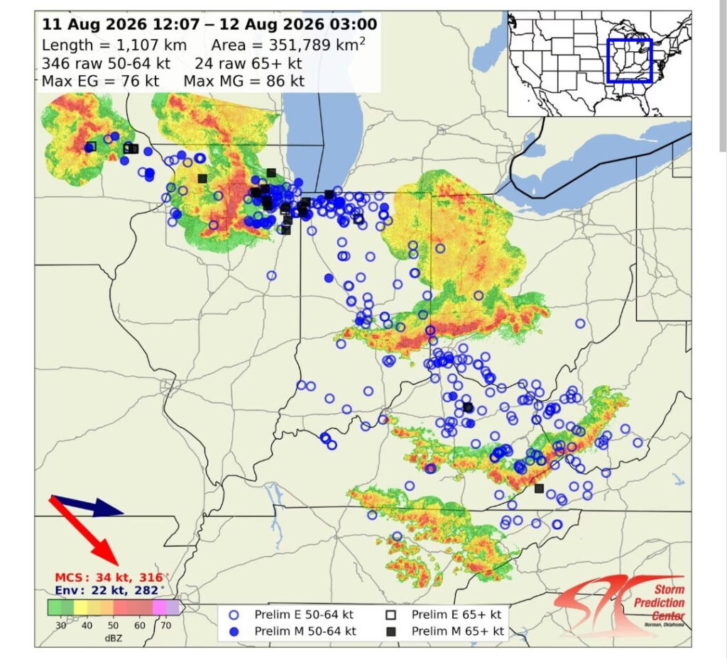
AVC News Photo; August 11, 2026 derecho (map courtesy of the SPC-NOAA)
The 200 plus mile derecho path began in eastern Iowa, entering northern Illinois and Chicago area, producing 99 mph winds, then moved into Northern Indiana, turning southeast into Ohio. It then traveled into Kentucky and finally into Tennessee.
To our west, the Indiana Dept. of Transportation reported that all westbound lanes of Interstate 70 were closed due to flooding damage in Wayne County near the Ohio border, which reported 24 hour rainfall totals of between 7 and 10 inches.
The Cincinnati-Northern Kentucky International Airport reported a wind gust of 59 mph during Tuesday’s storms, however localized wind gusts exceeding 70 mph were reported. Heavy rains and winds caused significant widespread damage in western Ohio.
In Central Ohio, storms produced heavy rain and high winds Tuesday morning. The John Glenn Airport reported a wind gust of 82 mph. The storm downed trees and power lines, damaged structures and flipped a vehicle on Interstate 71 near the State Fairgrounds. The incident was caught on an ODOT traffic camera.
Reports out of Northeast Ohio say 19 people were injured, two seriously, following a lightning strike at the Grafton Reintegration Center in Lorain County shortly before 5:30 pm Tuesday. The Ohio Dept. of Rehabilitation and Correction reported that the injured were all inmates of the prison and were walking across the prison yard after leaving the dining area. Two victims were in full cardiac arrest and others sustained burns of varying severity. At last word, four victims remained hospitalized, no deaths were reported.
In a related note; numerous services and donation drop off or pick up locations to benefit local flood victims have been identified by the Perry Co. EMA. The list, provided to AVC News is contained in a separate article on this website.
Last Updated on August 13, 2026 by AVC News